Using MODIS data as a means for identifying wildfire incidents that may be missing from NFIRS
Investigation of MODIS-Detected Fires in NFIRS8.
United States Fire Administration
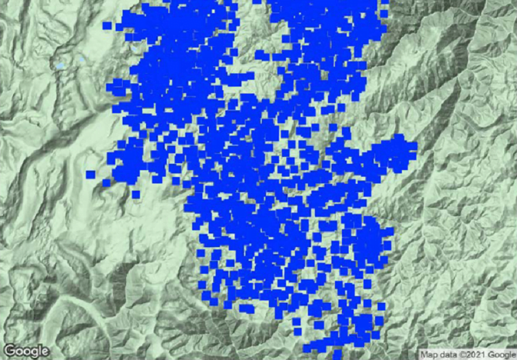
Moderate Resolution Imaging Spectroradiometer (MODIS)1 is a satellite-based instrument used to collect data about features on the Earth’s surface.
Scientists have developed algorithms to analyze that data to detect active fires. Researchers David T. Butry and Douglas S. Thomas published a paper in 20172 that compared the MODIS active fire data for California from 2003 to 2014 to wildfire incident data collected by the U.S. Fire Administration’s (USFA’s) National Fire Incident Reporting System (NFIRS) and found that only 32% of the MODIS-detected fires could be matched to an NFIRS incident.
In conducting this analysis, USFA’s goal was to apply a variation of Butry and Thomas’s MODIS/NFIRS fire incident matching process at the national level to determine if the same proportion of data could be matched in the rest of the U.S. Additionally, as a path to improving NFIRS reporting, it was thought that this could be a first step in determining the feasibility of using MODIS data as a means for identifying wildfire incidents that may be missing from NFIRS.
Using geocoded 2017 NFIRS data for all fire incidents in the U.S., USFA found that only 1.1% of the MODIS observations (or 1.6% of MODIS-identified incidents) occurred within 1 kilometer and 24 hours of any NFIRS-reported incident. It was determined that 6.4% of MODIS-identified incidents occurred within national parks and national forests, grasslands, and wilderness areas, but only a handful of these incidents appear in NFIRS data. As for the remaining unmatched MODIS-identified incidents, it is uncertain whether they occurred in other public lands; were small, controlled unreported fires; or were false positives.